Scientist of the Day - Pierre Puiseux
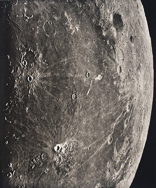
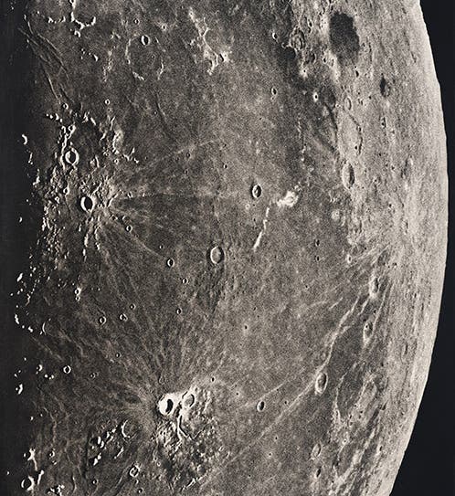
The lunar craters Grimaldi (dark crater at upper right), Kepler (center left), and Aristarchus (bright crater at bottom center), in the Ocean of Storms, Atlas Photographique de la Lune, Maurice Loewy and Pierre Henri Puiseux, 1896-1910, plate 57, taken Sep. 4, 1904 (Linda Hall Library)
Pierre Henri Puiseux, a French astronomer, was born July 20, 1855. He began working at the Paris Observatory in 1885, where he soon teamed up with Maurice Loewy, an Austrian Jew who had left Vienna seeking a country more hospitable for a Jewish astronomer. Puiseux and Loewy initially worked on a project known as the Cartes du Ciel, which intended to provide a complete photographic atlas of the stars, but the project, after some initial enthusiasm, withered and died. So the two decided to use the large astrograph (photographic telescope) at the Observatory to record images of the moon, and this enterprise was much more successful. They started taking photographs in 1894, and in 1896, they issued the first fascicule of their Atlas photographique de la lune. Each fascicule had 5-6 heliogravure prints of a section of the Moon and a descriptive text. The prints were quite large, about 24” x 30 ", and in most libraries, like ours, are shelved in flat folio boxes.
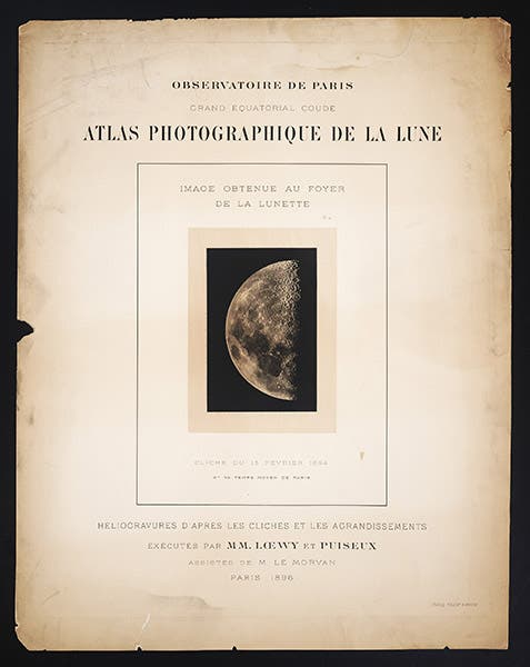
Title page to fascicule 1, 1896, Atlas Photographique de la Lune, Maurice Loewy and Pierre Henri Puiseux, 1896-1910 (Linda Hall Library)
The production of the Atlas continued until 1910, when the 12th and last of the photographic fascicules was published, with a total of 71 plates, followed by a 13th fascicule with an index. It wasn't really complete, but then, it was never intended to be an atlas in the modern sense, that is, a full map of the moon. It was rather a showcase of the Observatory’s finest lunar photographs, at various scales, with most lunar features recorded somewhere on the plates. And viewed this way, as a collection of outstanding lunar photographs, it was a grand success. As a collection, the Atlas would not be equaled until 1960, and some of the individual photographs have never been surpassed.
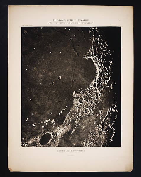
Mare Imbrium (Sea of Rains), at the northern end of the Ocean of Storms, with the bay called Sinus Iridium, and the Heraclides promontory jutting out at the top of the bay, Atlas Photographique de la Lune, Maurice Loewy and Pierre Henri Puiseux, 1896-1910, plate 11, taken Apr. 23, 1896 (Linda Hall Library)
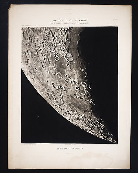
The northern horn of the new moon (north is down), with the crater Posidonius at the edge of the shadowed Sea of Serenity. The twin craters right next to each other below and to the left of Posidonius are Atlas and Hercules, Atlas Photographique de la Lune, Maurice Loewy and Pierre Henri Puiseux, 1896-1910, plate 28, taken Apr. 26, 1898 (Linda Hall Library)
We don’t know much about either man, although Loewy did become director of the Paris Observatory in 1896, just when the Atlas photographique began to appear. So for this occasion, we are going to showcase the Atlas. We have a near-complete set, missing the 12th fascicule and the index. But the 65 plates we do have are undeniably splendid, and I selected a few of them for you to view. Three of them are shown full size, just as they appear when you take them out of the folio case. Our first image has been cropped to the plate line, so you have a slightly larger image to view. We should note that all images have south at the top, as was the convention for lunar imagery until the 20th century. So when a caption describes a feature as at the north end of the Ocean of Storms, it is at the bottom.
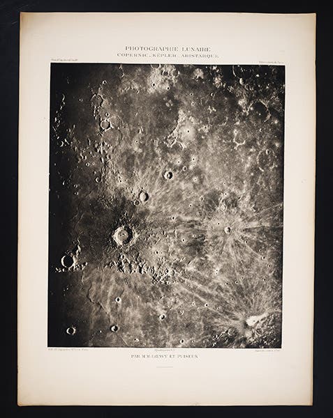
The lunar craters Copernicus (largest), Kepler (due right of Copernicuis) and Aristarchus (bottom right corner), in the Ocean of Storms, Atlas Photographique de la Lune, Maurice Loewy and Pierre Henri Puiseux, 1896-1910. Plate 16, taken Sep. 29, 1896 (Linda Hall Library)
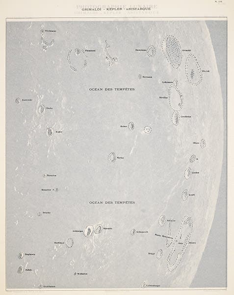
Tissue overlay for plate 57 (our first image), identifying the craters and other lunar features, Atlas Photographique de la Lune, Maurice Loewy and Pierre Henri Puiseux, 1896-1910 (Linda Hall Library)
One of the welcome features of the Atlas is that each plate has a tissue overlay, with the names of the more prominent craters and maria printed on the tissue (sixth image). This is such a superior way to identify features on a map, without cluttering the map itself with names, that one wonders why it was not used more often. We have written a post about one other publication that adopted this method of identification, and that was Louis Agassiz’s Études sur les glaciers (1840). I wish there were more.
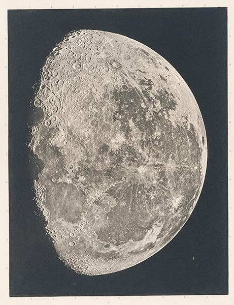
Detail of title-page vignette for fascicule 8, 1904, a photograph of the entire three-quarter moon, taken Oct. 12, 1900, Atlas Photographique de la Lune, Maurice Loewy and Pierre Henri Puiseux, 1896-1910 (Linda Hall Library)
We included a plate from the Atlas photographique in our exhibition on lunar cartography, The Face of the Moon: Galileo to Apollo; it was the full plate of our first image. When I was selecting a plate for that exhibition, I noted that each fascicule has a small photogravure of the entire moon as a vignette (second image), but I did not notice at the time that each fascicule title page has a different vignette. They are wonderfully sharp, so they withstand considerable enlargement, and I include one here, as it appeared on the title page of the 8th fascicule, showing a three-quarter moon (seventh image).
William B. Ashworth, Jr., Consultant for the History of Science, Linda Hall Library and Associate Professor emeritus, Department of History, University of Missouri-Kansas City. Comments or corrections are welcome; please direct to ashworthw@umkc.edu.

![Bivouac on Jan. 26 [1854], chromolithograph from a sketch by Balduin Möllhausen, Explorations and Surveys for a Railroad Route from the Mississippi River to the Pacific Ocean: Route near the Thirty-Fifth Parallel, by Amiel W. Whipple (Pacific Railroad Report, 3), 1856 (Linda Hall Library)](https://assets-us-01.kc-usercontent.com:443/9dd25524-761a-000d-d79f-86a5086d4774/55140a90-4b5d-4dac-832c-5def5cb51a10/Whipple1_cover.jpg?w=210&h=210&auto=format&fit=crop)
